The Global Positioning System – GPS
is a satellite navigation system allowing the determination of (absolute) real-time position on or around the Earth’s surface with an accuracy of a few meters.
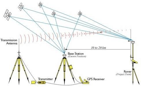
GPS measurements determine the location of a given point on earth, which from a specialist’s point of view means that spatial coordinates are measured in a certain geocentric coordinate system. GPS measurements reflect the process of coordinate determinations with GPS receivers.
We offer the following services in the field of GPS measurements:
- Measurement of geodetic networks for the needs of the cadastre;
- Creation of transformation parameters for transition from one coordinate system to another;
- Engineering geodetic measurements (roads, creating a digital model of the relief, tracing areal and linear objects);
- Determination of control points necessary for the production of orthophoto plans;
- Measurement with geodetic GPS receivers and processing of the results.